from the Controller's viewpoint
|
One of the important features of our Orienteering
arrangements is the role of the Controller of an event.
At Level C and above, the qualified Controller should come from a
club other than the organising club: this is a principle well worth
preserving. So when I was approached by BOK to control their
SWOA Galloppen event at Wavering Down at the end of November, I was
pleased to accept – in spite of the difficulties I knew I would have
because of the distance, because of my work commitments, and because my
son was getting married only a short time before! |
|
|
|
The job of the Controller is essentially to ensure
that the event provides a quality experience for all participants.
I was fortunate that BOK have a well established set of
procedures, with nominated teams, for all the organisational aspects of
putting on an event, so these did not occupy a great deal of my time.
This meant that I could concentrate on the quality of the courses
themselves, and have useful discussions with the Planner, Richard
Raynsford. The main areas of concern are always the same, I
believe: 1
Are the control sites fair and appropriate for the level
of competitor expected to visit them? 2
Are there appropriately challenging routes between
controls, with adequate attack points? 3 Are the course lengths appropriate, given the physical demands, especially the amount of climb? |
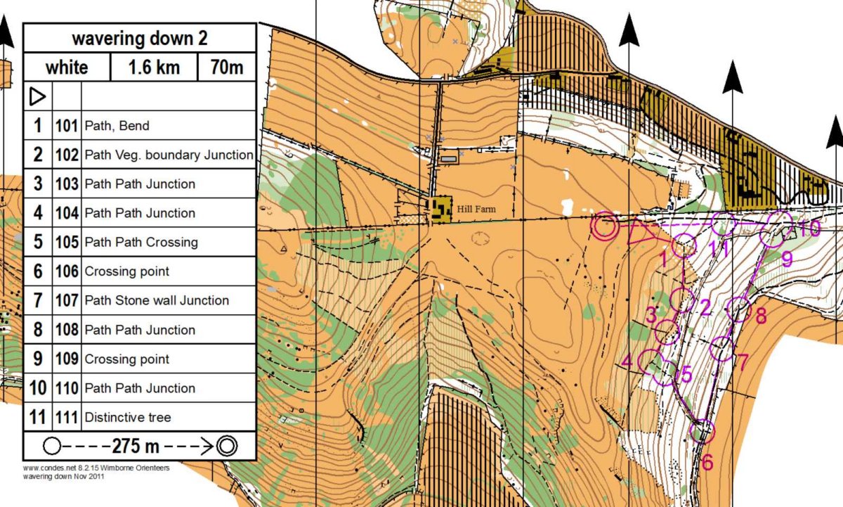
| Wavering Down is a largely open area, with a significant slope on its southern side, and without many obvious tracks and paths. At the eastern end, there is a wooded area, with a limited path network. Richard sensibly opted to use this area for the White and Yellow courses – which would also have given younger competitors some shelter if the weather conditions turned out to be bad. | |
|
|
|
|
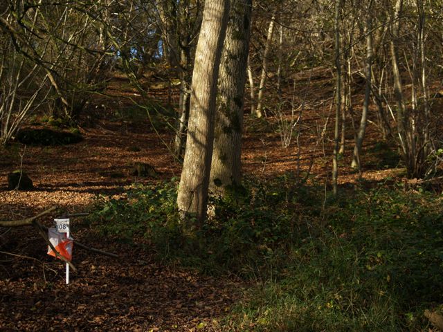
An important issue on White and Yellow courses is to place control markers at junctions in such a way that competitors should be clear about the options and therefore their best route. On the day, although we thought we had done this, we found that some White competitors were taking the wrong route out of Control 8 (108). It might be helpful for parents and teachers to review this with their competitors who may have gone wrong. At this point competitors are faced with a fork in the path: the Left fork is the one White competitors should select. Some however took the Right fork. Reasons for this might include (a) the R fork is the continuation of the major path while the L fork is a more minor path, and (b) the Yellow course did use the R fork so there were competitors running confidently that way. However, apart from the L fork being “straight on”, (a) a compass bearing would have shown that it was heading almost due N as required, while the R fork heads NE, (b) the L fork continues at the same level while the R fork goes downhill, and (c) the L fork stays surrounded by the wood while the R fork has an open field on its right side. On the longer courses, most of Richard’s selected
control sites worked well. We
agreed together to eliminate a couple of early suggestions of controls
on vegetation boundaries which were not as definite as I would have
liked. We eliminated from
the first draft of the Orange course a control in the open which had no
obvious nearby attack point and no catching feature close beyond –
this would have been particularly difficult in poor visibility. |
|
|
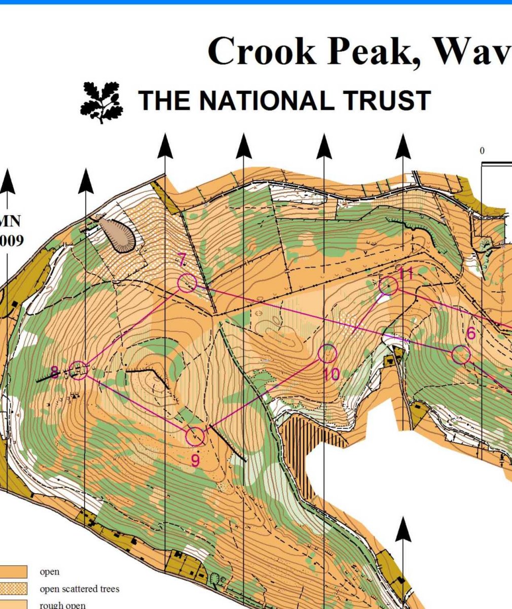
For the longer courses, the shape of the area (relatively narrow) limited the route choice possibilities unless competitors were to be asked to run up and down the scarp slope too many times! This would have meant shorter courses and not using the western area of the map, Crook Peak. However, we did reverse the Brown and Blue courses from the original intention. They both had the leg shown on the map extract (blue, 7-8). Originally this
would have been run the other way and would have been very
straightforward: a fast run downhill towards the visible fence corner
and aiming to the NW of the green, with no danger of going much too far.
Reversing it meant that there was choice: compass and contour, or
use the crag on the peak as a clear attack point and approach the
control from the W end of the crag. |
|
|
Course lengths were the other main issue, as I felt
the original courses were too long, given the amount of climb.
The more physical the area, too, the greater the spread of times
between first and last: I did not want anyone to be out on the hill for
an excessive amount of time, given its exposed nature.
So, using the evidence of the previous event at Wavering Down,
courses were shortened from those originally planned.
Again, I think we got this about right as winning times were
appropriate, and almost everybody finished within twice the winner’s
time. We were fortunate in
the weather conditions on the day as I am sure that wetter conditions,
or poor visibility, would have resulted in slower times particularly for
the less experienced. Controlling an event may also improve the Controller’s own orienteering skills (I wish!). Visiting the area to check out control sites means that you are on your own, with nobody kindly leading you into the control site, and there are no friendly red and white kites to reassure you that you have found the selected feature. I much enjoyed the overall experience and the views from Wavering Down on all my visits, and especially on the day of the event itself, were magnificent. Martin Cross |
|
.jpg)