SmartPhone Orienteering - an encounter with MapRun
QO night event, Yeovil, Feb 28th
The modern smartphone is a remarkable example of convergent technology. One device can be used for many tasks: as a small internet connected computer for texts, email, tweets, facebook postings etc; with earphones as a music player, as a radio, or even for watching TV and video; as a camera; as a torch and, using the built in GPS, as a navigational aid. It can even be used as a phone!
But at the Quantock Orienteers night event in Yeovil a few days ago, it was used to replace control flags, SI boxes and dibbers, even the map, using a free phone app called MapRun.
The MapRun app, and its sister app, MyOMaps, were developed in Australia, with the assistance of sponsorship from the Australian Sports Foundation. It is now used in many countries, with NGOC & QO beginning to use it for low key urban events in the South West.
To quote from the QO website:- "MapRun, also known as MyOMaps, doesn't need kites, control units or permanent course posts."
Basically, MapRun relies on GPS readings (pinpointed from Google Earth) of locations of street furniture, typically lamps and post boxes. Quite a few people will already be familiar with urban score events using street furniture where you take a note of say a lamp post number to prove you've visited the site.
With the new method, your control 'punches' are registered via a smartphone, which vibrates or buzzes when you're within about five metres of the control. First though you need to download the event onto your MapRun app and activate your run via a PIN code obtained from the organiser. Afterwards you have the option to upload your result onto the event leaderboard online, via a single click. Automatic postings to RouteGadget are possible for some events.
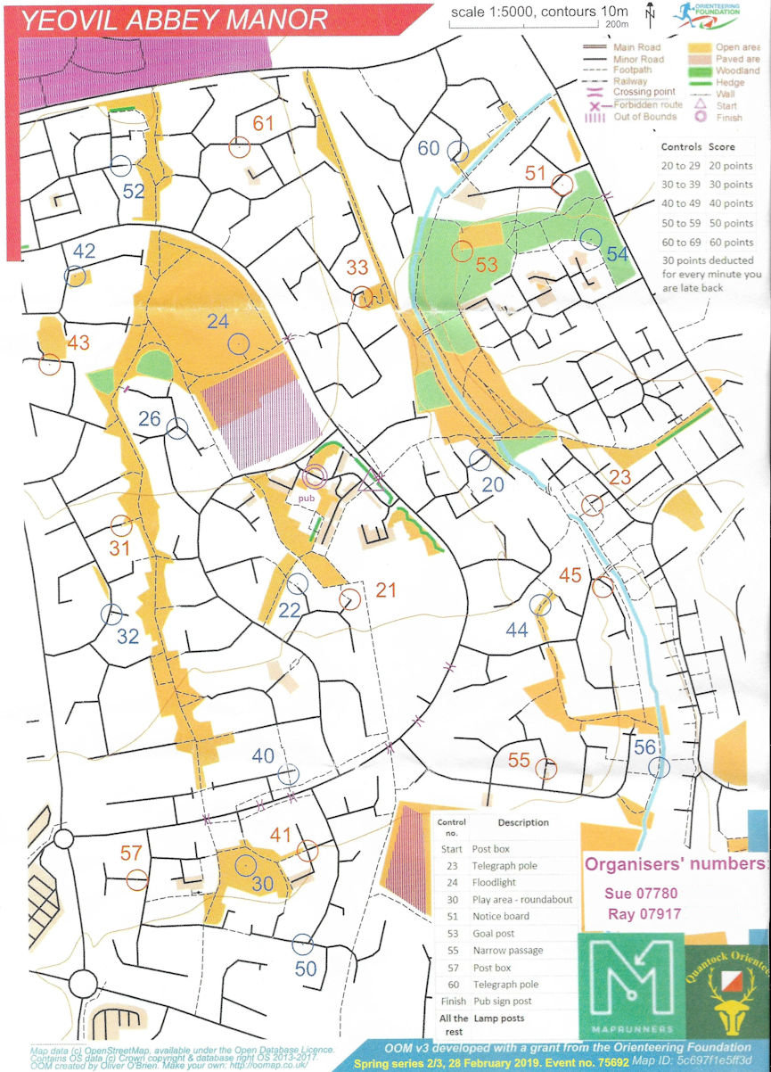
The instructions on the QO website were very clear. They use maps generated by the Open Street Map website, which are geo-referenced, with control circles based on lamp posts, telephone poles, post boxes, although you can use conventional OCAD maps. You could download the map file onto MapRun on your smartphone beforehand, or at the event, although it wasn’t accessible to view until a pin code was put into the system. The event began in the daylight, with the option to run either in daylight or as a night street evet. But by the time I had struggled through the Yeovil rush hour traffic and the endless roadworks, I was definitely going to need the headtorch.
At the event, on payment of the £5 entry fee to the Organiser sitting in his van in a pub car park, I was given a printed map (waterproof paper – very necessary on a wet and windy night) and the pin code. When I put the code into the app, the map and course appeared on the phone screen. The organiser pointed out the post box on the roadside which was being used as the Start. I wandered over to it, whereupon my phone emitted a loud beep and I was off, headed for the nearest control circle and another satisfying beep.
I found it easier to put my phone in a pocket, rather than using the screen for the map, and relay on my paper map for navigation, and, for a while at least, every time I found myself in the vicinity of a control the phone beeped. Eventually, because I’m very slow these day at the best of times, I had a longer leg and the phone went to sleep and dropped the gps connection so that I got to the centre of the circle and nothing happened. But I managed to change the phone settings, restarted the app and everything continued again.
I was struggling a bit with a virus, so when the rain began in earnest after 35 minutes or so, I decided to wimp out, cut my route short and return to the pub car park, making sure that the phone beeped at the Finish.
Then it was a simple matter of uploading my results from the phone to the system whilst standing in the car park, and lo and behold, when I looked at the results, there I was, last as usual. Furthermore, the app connects to a Routegadget page for the event, on which my gps trace was already marked on the map. You could see clearly to the points at which my phone turned itself off and when I turned the gps back on.
MapRun enables clubs to hold low key events without the need for flags, dibbers, SI control stations. As such it's very suitable for training, very low key events (you can even leave the competition open for a couple of days for folk to turn up and run at a time convenient for them) and a variety of other uses. For example, we could upload some of our permanent courses, like ByTheWay.
MapRun is free to download. Course and event administration is by way of a sister app, MyOMaps, which need to be paid for (all of £3.32) and is used by the organising clubs to set up events.
It is definitely something which WIM should consider using in the future.
Dick Keighley
Useful Links: Quantock Orienteers website https://www.quantockorienteers.co.uk/
MyOMaps amd MapRun apps: http://www.myomaps.com/
Useful YouTube video showing a Hungarian event using MapRun: https://www.youtube.com/watch?v=eargTU3K3Bo&feature=youtu.be&fbclid=IwAR3EMWzfbvvM8MbIqDtDZDds_6DXJ8c2IdwSe_FWb9lR-Z445cgMBmCKf38