An introduction to Lidar
LiDAR (Light Detection and Ranging) data is published in the UK by Geomatics, an arm of the Environment Agency. It is the technology of collecting detailed information on height above sea level through aerial sensing. It measures distances by firing laser beams at the land below and analysing the reflected light. It can detect not only ground levels but above ground features such as buildings and areas of vegetation.
The Geomatics website is at
https://www.geomatics-group.co.uk/geomatics/login.aspx
and the data is available as 1km or 500m square tiles depending on its resolution. To obtain data you register for an account, log in and select the tiles you want. You need to declare it's for non-commercial purposes or you'll be charged a hefty 3-figure sum! Happily, orienteering is deemed a valid non-commercial use. I ordered one day and received download instructions the following day.
You can get 25cm, 50cm, 1m or 2m ground resolution. Coverage is patchy though, with finer detail in some areas than others, and there is no data at all in some areas. For example, the Golden Cap estate which I've recently been mapping has about 90% coverage at 1m, limited areas at 50cm, and nothing at 25cm.
The Lidar DEM (Digital Elevation Model) comprises two types of information. It is either
DTM (Digital Terrain Model) which is ground level height data, or
DSM (Digital Surface Model) which is data about the tree canopy, buildings etc.
Sorry about the jargon rush but we are in IT terrain!
You can also obtained hill-shaded jpeg tiles from Geomatics. They're excellent for visualising landform shapes but of limited use as templates for drawing maps. Google Maps or Bing will show much finer detail.
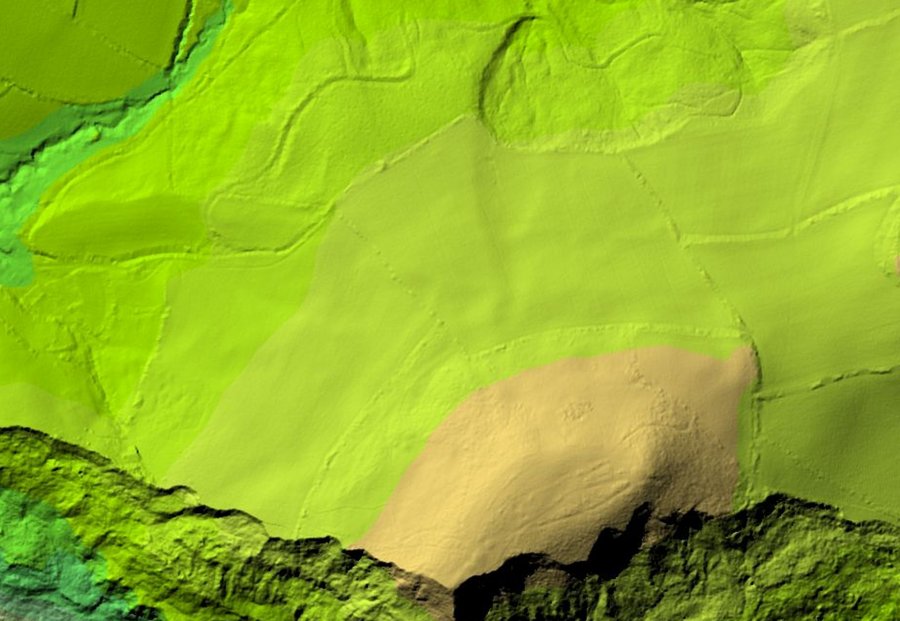
Part of Golden Cap estate. The E half of this image
is the W part of the contour map below.
DTM data is of immediate interest to mappers as, when processed, it provides accurate contour information. For Golden Cap I got two DTM 1km tiles, SY4092 & SY4192, at 1m resolution. This equipped me with a basemap of contours at 1m intervals for about 90% of the area. 5m and 25m contours were distinguished by different colours. It was a pleasure to work with, light-years away from the generalised contours of an OS 1:25k Explorer map!
DSM is the means of identifying man-made and vegetation features. By comparing it with DTM, it enables you to identify features at different heights so you can, for example, tell gorse bushes from bits of woodland. I've seen the results of this but haven't tried it yet. I went on a course to learn about it but the vanishing site caretaker had failed to unlock the IT Suite, much to the embarrassment of our experienced course leader who pluckily improvised with a flipchart in a scout hut!
Lidar tile data is in ASCII format - pages and pages of unintelligible characters and numbers. To make sense of it requires specialised conversion software. Ocad 10 & 11 do the job supremely well. So folks, you just need a spare 580CHF (£400) or a Good Friend who has Ocad 11 and will do the job for you.
If you want a high-res jpeg contour image to use as a basemap template, there are free open source programs like QGIS that also convert raw data into raster images, but they don't have the advanced features of Ocad 11. If comparison of DTM & DSM data and map generation is your aim, Ocad is the way to go. Free programs like OpenOrienteering Mapper may hopefully catch up with Lidar processing but they aren't there yet.
There are many different ways of using the files produced from Lidar. Personally, being some way into mapping Golden Cap, I used the Lidar map as a template to correct and improve what I'd already done; I didn't start with it. If I had Ocad 11 and had known about Lidar before I began, I daresay I'd have done things differently.
The image below is a Lidar contour map of part of NT Golden Cap estate west of Bridport. 1m contours are in grey, 5m in blue and 25m in purple. The map is approximately 800m wide. It illustrates the elevation detail that can be extracted from Lidar. If you compare it with an OS Explorer map of the same area, you'll notice how much fine detail is lost due to the generalisation necessary to make a legible 25k map. Orienteering maps are usually 1:10k or 1:15k so need to be based on the sort of high quality landform information Lidar can provide.
And of course, never put blind faith in digital information. Lidar is brilliant, but it doesn't replace the eye and brain of the surveyor, trudging through changeable weather and arduous terrain to check odd features in even odder places!
Mike Kite
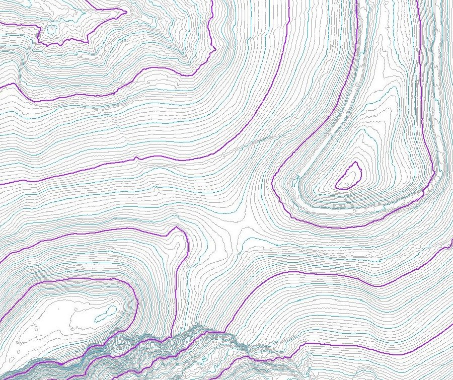
Golden Cap is in the SW; Langdon Hill in the NE.